Monthly weather forecast for the UK
Updated 29th Jan - Covering 5th - 27th February 2024
Slowly and erratically turning colder from the north after a mild start, probably cold and mostly dry by late February though with potential for wintry showers
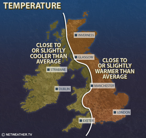
Relative to the 1991-2020 long-term average, this period looks set to be colder than normal, typically by between 1 and 2C in Scotland, but in south-east England temperatures may end up within 0.5C of the long-term normal due to the milder air taking a while to shift early in the forecast period.
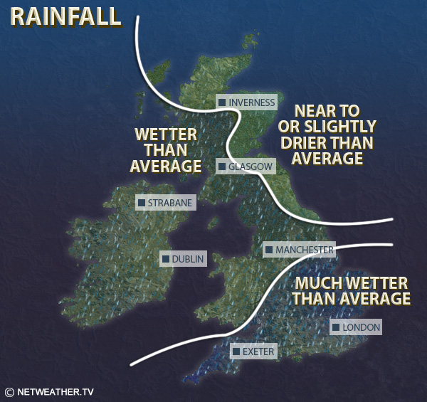
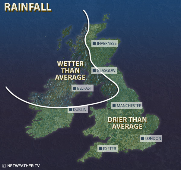
Despite a wet start to the forecast period, most regions, especially western Britain, will probably come out drier than normal. Eastern and southern England, especially near North Sea coasts, are the most likely regions to see near or slightly above average precipitation.
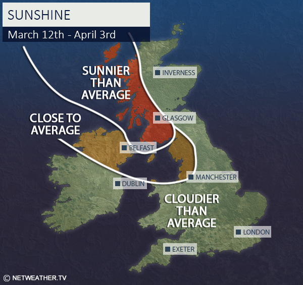
Sunshine is forecast to be well above normal in western Scotland, Northern Ireland and north-west England, and probably above normal in most other regions too, but it may be cloudier than average in parts of southern England.
More Weather Forecasts & News


Week 2: Monday 5th February - Sunday 11th February
This week will see the high pressure to the south slowly decline, while pressure will fall over Scandinavia, but it looks unlikely that a Greenland blocking high will develop during this week. Thus, there is an increasing chance of colder north-westerlies developing as the week progresses, especially in northern Britain, but there will also be some mild spells via westerlies and south-westerlies, particularly in the south and particularly early in the week.
At the beginning of the week, there will be a northwest-southeast split in the weather, with the north and west of Scotland generally seeing the wettest and windiest weather, and mainly dry weather in central, southern and eastern England, with a fair amount of sunshine in the east of England but cloudier weather in the west of Britain. But as the jet stream increasingly pushes further south, towards the end of the week it is likely to be wettest in southern Britain, where it will often be mild and wet with slow-moving frontal systems, while further north, particularly in Scotland, it will often be brighter with some increasingly wintry showers and overnight frosts as colder north-westerlies set in.
Mean temperatures, relative to the 1991-2020 long-term normal, are forecast to be between 1 and 2C above normal in most parts of England and Wales, with the highest anomalies in south-east England. However, much of Scotland and Northern Ireland will be closer to normal, and northern Scotland may come out up to 1C colder than average.
It will end up wetter than average in most parts of the UK, with the north generally being wet early in the week, and the wettest weather transferring to the south late in the week, but it currently does not look likely to be exceptionally wet.
Overall, sunshine will probably come out above normal in most parts of Scotland, due to a sunny end to the week, and also in eastern England, where it will be sunny early in the week, but it will probably be below normal in Wales and south-west England.
Week 3: Monday 12th February - Sunday 18th February
During this period there is an increasing chance of high pressure building to the west and north-west of Britain, with potential for a Greenland blocking high to emerge late in the week. This means that we will continue to see north-westerly winds, especially in the north. There is also an increasing chance of colder northerlies pushing into all parts of the country at times, especially in the second half of the week, bringing sunshine and potential for some snow, particularly in the form of showers in northern Scotland and near north-facing coasts. Frost will become widespread at times, particularly in the north. However, there will be some milder, wetter interludes, particularly in the south and particularly early in the week.
Overall this week is likely to be colder than average in most parts of the UK, but probably not exceptionally so, as it may take a while for the cold northerlies to establish widely, with negative anomalies of 1 to 2C in most regions. In the south, where it will sometimes be milder, especially early in the week, temperatures may come out very close to normal.
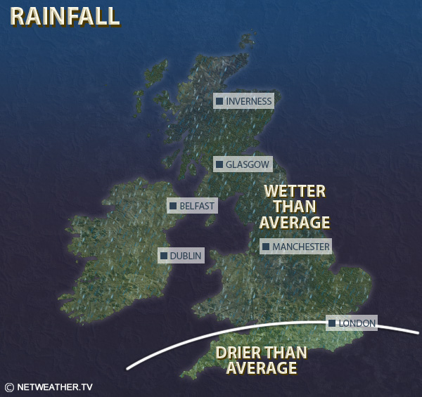
It is expected to be drier than average in most western parts of the UK, particularly Northern Ireland and western Scotland, but wetter than average in the south-east.
Sunshine totals are forecast to be above normal for most regions, especially north-western Britain, but it may be cloudier than average in southern England.
Rest of month: Monday 19th February - Tuesday 27th February
This period will probably be predominantly dry and settled with high pressure often ridging into the British Isles, but with highest pressure often to the north-west of the UK, there is potential for some northerly or north-easterly blasts, which may bring some wintry showers to northern Scotland and to eastern counties of both Scotland and England. It will probably be colder than average for the majority of the period, with widespread frosts at night.
Overall, it looks likely to be on the cold side, but with a fair amount of uncertainty over how cold relative to normal, with a most likely outcome of around 1-2C below normal for most. It looks set to be drier than average almost everywhere, with the possible exception of some eastern coastal counties. Sunshine is likely to be above normal in western and especially north-western Britain but probably near normal in the south and east of England.


Monthly weather forecast
The month ahead forecast is written by Ian Simpson and is updated every Monday.
Site Search